


A Guide to Drone-Based Commercial Roof Surveys
Drones are quickly becoming one of roofing contractors’ most useful tools. They offer numerous benefits, both for the customer and the contractor, and can supply helpful data that can influence decision-making, help diagnose problems, and reveal damage. D. C. Taylor Co.’s Andrew Tyrrell, Project Representative and licensed unmanned aerial vehicle (UAV) pilot, offers practical tips on who to hire and what to expect.
Roof-Related Drone Capabilities
Commercial roofs with steep slope, no easy access, or deteriorated decking are ideal candidates for a roof inspection conducted by a drone. “Any roof that is going to require a lot of fall protection for us to get on, this is just an easier way to do it,” notes Tyrrell. There are no concerns about the roofing professionals safely traversing the roof, and, likewise, there’s no need to deliver a mobile elevated work platform for accessing a tall structure like a grain bin. The facility professional and contractor stay on the ground while the drone flies over the roof. It’s not only safer, but also faster and more convenient.
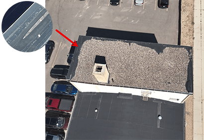
A roof survey conducted by a drone will take measurements of the roof and produce high-resolution photographs of the surface, which is helpful in inventorying roof components (e.g., penetrations, drains, HVAC equipment, skylights, etc.) and identifying deficiencies. “With a 4K camera, we’re able to capture high-resolution photos of ponding water, flashings that are failing, and any big tears in the membrane,” says Tyrrell.
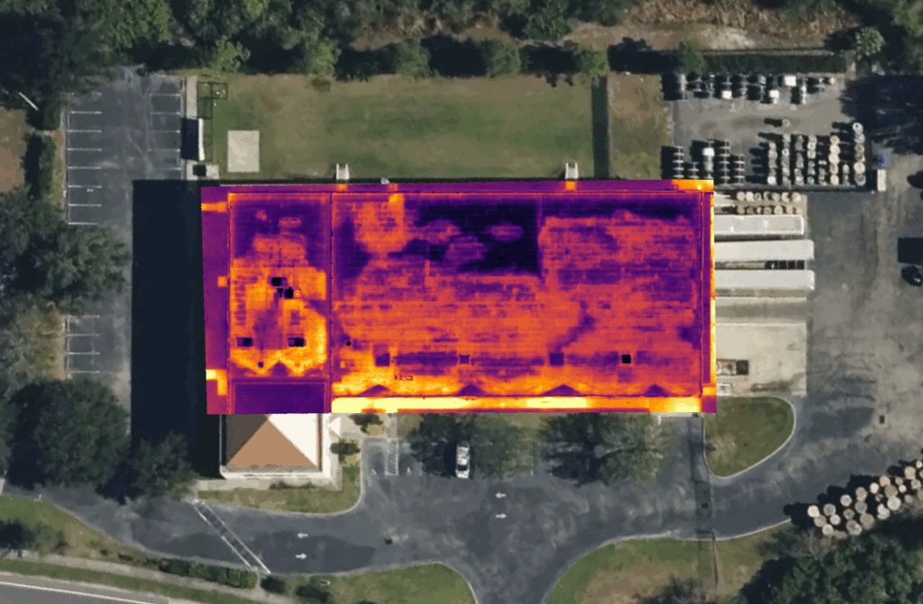
Equipped with an infrared camera, a drone can also capture thermal anomalies on the roof. These are areas of the roof that are hotter than their surroundings (i.e., giving off more heat energy). The temperature differences may be indicative of the presence of moisture. Once areas have been identified via a thermal scan, additional investigation (sometimes with core cuts) is necessary. “On some projects where we’re going to spot replace insulation if it’s wet, this is a good tool to help us find those areas,” explains Tyrrell. Additionally, when the source of roof leaks is difficult to discern and recreating the leak by spraying the roof with water isn’t possible or practical, a thermal scan can provide valuable clues about the origin of the problem.
What to Expect
Before a roofing professional can use a drone to perform a roof survey or thermal scan, they’ll make sure the facility isn’t in a no-drone zone. “The only things that would keep me from flying are weather conditions and if the building was in restricted airspace. I always check air maps and get LAANC (Low Altitude Authorization and Notification Capability) approval if needed,” explains Tyrrell.
Rain, fog, snow, or high winds can reduce visibility, make controlling the drone difficult, and increase the risk of a crash. On clear days, however, you can expect the drone flight to take a minimum of 30 minutes. “It can take 3 hours or more for a big facility with multiple roof areas,” he says. This allows time for setup and teardown, as well as changing batteries.
Time of day matters when using thermography. “The best time to do a thermal scan is just before dawn and probably 30 minutes after dusk because [the camera] is picking up temperature changes. If everything’s getting hit by the sun, it’s going to all be the same temperature. Once the sun goes away, then your surface starts cooling,” Tyrrell shares.
While it’s possible the drone pilot will share with you in real-time what is visible during the flight, it’s more realistic to expect to receive a photo report with the findings after careful review and analysis of the images has taken place.
Criteria & Qualifications: Who You Hire Matters
“Make sure that the pilot in command has a Part 107 license. It’s best if they have some experience and are not just a hobbyist with a drone. Insurance is important too in case they were to fly into anything and cause damage,” advises Tyrrell, who went through online drone pilot school and then Federal Aviation Administration (FAA) testing to get licensed. He also became a level 1 thermographer after taking a FLIR (Forward-Looking Infrared) thermal certification course. This taught him how to interpret the thermal data, distinguish between what’s an anomaly and what’s simply hot from the sun, when the best time to scan is, and how to use the software.
Ask about the qualifications of contractors pitching you their drone capabilities, and make sure they are using professional commercial-grade equipment and software specifically developed for mapping, analysis, and reporting.
Interested in a drone survey or thermal scan? Contact D. C. Taylor Co. at 319.731.4118 or [email protected].